


The standard version goes like this: the world ends, the cities empty all at once, and the people pour out into the countryside like a swarm of locusts, stripping everything bare as they come. It gets repeated at every prepper campfire. What it almost never gets is examined. In my opinion, the Golden Horde has almost become the prepper equivalent of a campfire ghost story — one repeated but never believed. Most people never sit down and actually run the numbers to see what it would look like in reality.
So let’s run them. Not to debunk the horde — it’s real — but to measure it. Because once you measure it, it stops being a swarm and becomes three things you can actually know for your address: a population, a distance, and a road network.
Start by conceding the part that’s true
Two rules hold up, and I want to grant them up front so it’s clear this isn’t a “nothing to worry about” piece:
- People fleeing something are probably pretty desperate.
- Desperate people are dangerous.
Put those together and a large group of displaced people is genuinely dangerous — and not only the criminals among them. Even good people, just trying to keep their kids alive, become a threat when they’re desperate enough. That’s the real risk. The question isn’t whether it exists. It’s how big it is, and whether it reaches you.
First measure it as a circle
The first pass is deliberately crude, because a crude model still beats a ghost story. Take a metro of 350,000 people that has to evacuate with no notice. Some always stay, so call it 90% who flee — 315,000 people. Now let them spread out uniformly in every direction until they thin to about 40 people per square mile, roughly the density a rural area can absorb.
That’s simple math (you do remember the area of a circle, right):
- Population ÷ rate = area. 315,000 ÷ 40 = 7,875 square miles.
- √(area ÷ π) = radius. √(7,875 ÷ 3.14) ≈ 50 miles.
Live inside that 50-mile circle and you should expect to see refugees. And here’s the catch the ghost story misses in the other direction: almost nobody has just one city near them. Draw every metro’s circle and, across most of the eastern U.S., they overlap. The overlaps are the places where the incoming density blows past what the land can support — the “do not be here” zones in a full evacuation.
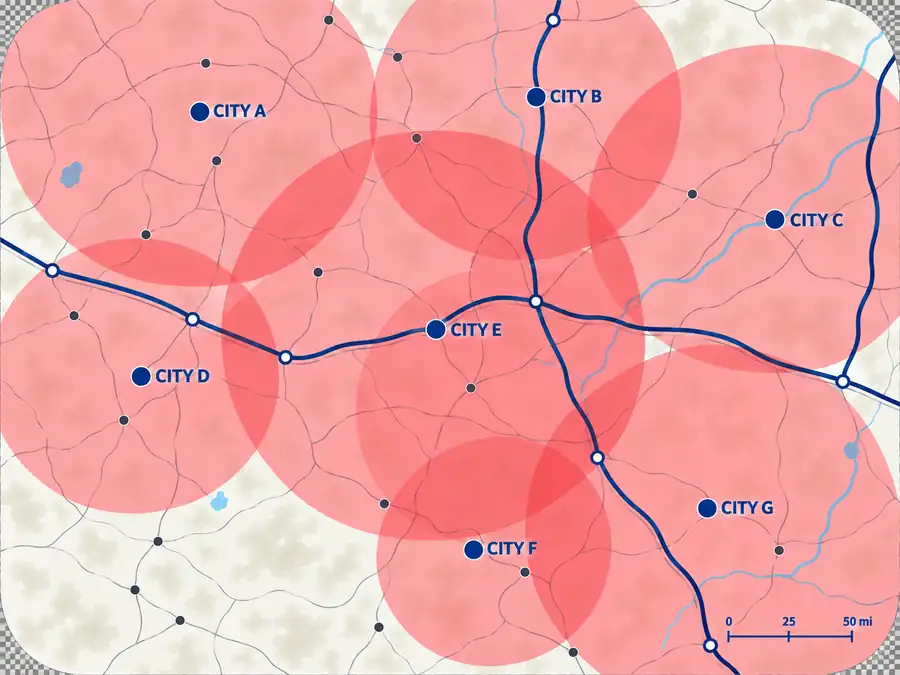
Now, I’ve given you the math so you have the background, but you don’t actually need to do this - we’ve done it for you. The Recon tool has a population pressure layer that will show you exactly what you face in this area (distributed by county instead of hard circles).
Then remember they can’t teleport
The uniform circle is a fiction in one important way: people don’t disperse evenly, and they don’t get infinitely far. They travel — and travel has limits.
By car. The average vehicle has a highway range around 450 miles, and, statistically, the average tank is about half full at any given moment. Multiply them and the average car gets roughly 225 miles before it’s dry — and then its occupants are on foot. People imagine topping off or siphoning; in a real evacuation the stations sell out fast, and with the power down the pumps don’t work at all. Range doesn’t extend much in practice.
On foot. Being generous, call it 6 miles a day for an average family — slower than a fit backpacker because of weight, fitness, kids, and the elderly. FEMA’s survey tells us the average household has about a week of food. Seven days of walking is roughly 42 miles; stretch it another three days on water alone and you reach maybe 285 miles from home before an average family simply can’t go further.
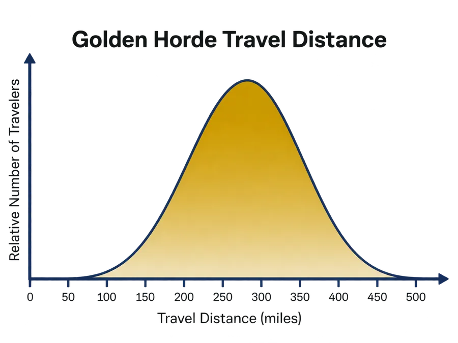
That number is the whole game. It means the danger isn’t uniform — it concentrates. People near a city drive through your area with range to spare. The ones who strand near you are the ones who started far enough away to run dry right about where you are. Now, this of course assumes that they have a destination that’s past you. If a major destination sits between you and the source, you may not get anyone. This is where the next piece of the puzzle comes into play — how people travel.
The paths are roads, not a compass rose
People don’t scatter in a circle. They follow rules, and the rules are predictable:
- They move away from the threat, in the direction opposite the thing they’re fleeing.
- They’re lazy — they follow established routes, even on foot. Highways and rail lines, not open country, and especially not across fences or rough terrain.
- They go where they’re familiar: family, a place they once vacationed and think is safe, another city.
- They seek milder weather — in winter they head south; in summer, toward relief from the heat.
Map the real routes out of each city with those rules, split the fleeing population across the paths, and you’ve turned a circle into a set of corridors. Most corridors miss you entirely. Usually one or two don’t.
What actually reaches your door
Here’s where we get to the number that matters for our example. Take that 315,000-person evacuation, split across four main routes at 25% each — about 78,750 people per path. Let’s say three paths miss us; one comes within 30 miles. Work the fuel math for the turnoff toward us and most of those people sail right past with fuel to spare. Only the ones who strand near the turnoff are a problem, and after you subtract the ones who keep driving and the ones who never leave their cars, the number who could actually walk to the door falls to a couple of percent.
In The Ultimate Preparedness Framework™ I go through the rest of the math in detail. But the summary is that in this scenario about 200 people end up at your door — down from a headline of “78,750 coming your way.” Two hundred is a serious problem. But it is a completely different problem than 78,750, and you can only see the difference if you do the math instead of repeating the story.
Two things fell out of running this for my own location. First, only a couple of population centers actually pertain to me — and not the ones I’d assumed. Second, and most important: being off the major routes is the single biggest thing that spares you. The corridors carry the horde. Distance from them is protection you can’t buy later.
Short-term and permanent are two different threats
One last distinction the single word “horde” hides. A hurricane evacuation is a short-term migration — people leave, and in days or weeks they go home. A city made permanently unlivable — no power for the long haul, an attack, contamination — produces a permanent one, and those people are not going home. Same crowds on the same roads; completely different problem for the people downstream. Know which one you’re modeling.
Bottom Line
The horde isn’t a myth, and it isn’t a locust swarm. It’s a population, a distance, and a road network — and all three are knowable for your address.
- Measure, don’t repeat. The circle, the fuel range, the foot range, and the corridors turn a ghost story into a threat you can size.
- Roads are everything. The people who reach you come down established routes. Distance from the major ones is your best protection.
- Know your handful. Most people have only one or two population centers that truly bear on them. Find yours, and you know what you’re actually preparing for.
The book helps you do this by hand with maps and a highlighter — the same math against real roads and real population data for wherever you live. Area Recon maps the routes and cities around you so you can see the corridors digitally, but can’t help you model this threat completely.